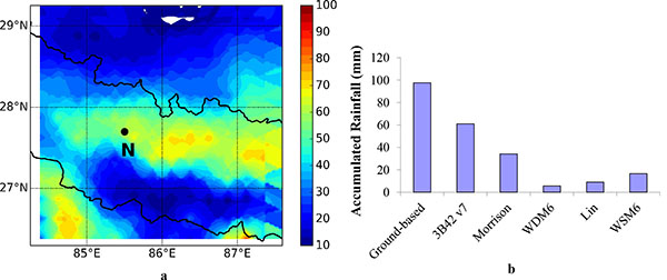
Fig. (4)
33 hours accumulated rainfall (mm) a) spatial distribution, represented by colour contours, over the study domain derived from the Tropical Rainfall Measuring Mission (TRMM) version 7 (3B42 v7) data. Ground-based measurement site (Nagarkot, Lat: 27.7 °N, Lon: 85.5 °E, Alt: 1900 m asl) is denoted by a black circle and a letter N, thick black line represents country boundary, and b) comparison between simulations and observations at Nagarkot station.