- Home
- About Journals
-
Information for Authors/ReviewersEditorial Policies
Publication Fee
Publication Cycle - Process Flowchart
Online Manuscript Submission and Tracking System
Publishing Ethics and Rectitude
Authorship
Author Benefits
Reviewer Guidelines
Guest Editor Guidelines
Peer Review Workflow
Quick Track Option
Copyediting Services
Bentham Open Membership
Bentham Open Advisory Board
Archiving Policies
Fabricating and Stating False Information
Post Publication Discussions and Corrections
Editorial Management
Advertise With Us
Funding Agencies
Rate List
Kudos
General FAQs
Special Fee Waivers and Discounts
- Contact
- Help
- About Us
- Search


Open Environmental Sciences
(Discontinued)
ISSN: 1876-3251 ― Volume 10, 2018
Environmental Degradation in the Ikorodu Sub-Urban Lagos - Lagoon Coastal Environment, Nigeria
Shakirudeen Odunuga*, Samuel Udofia, Opeyemi Esther Osho, Olubunmi Adegun
Abstract
Introduction:
Human activities exert great pressures on the environment which in turn cause environmental stresses of various intensities depending on the factors involved and the sensitivity of the receiving environment.
Objective:
This study examines the effects of anthropogenic activities along the sub-urban lagoon fragile coastal ecosystem using DPSIR framework.
Results:
The results show that the study area has undergone a tremendous change between 1964 and 2015 with the built up area increasing to about 1,080 ha (17.87%) in 2015 from 224 ha (1.32%) in 1964 at an average growth rate of 16.78ha per annum. The nature of the degradation includes an increasing fragility of the ecosystem through the emergence and expansion of wetlands, flooding and erosion as well as a reduction in the benefits from the ecosystem services. Population growth, between 2006 and 2015 for Ikorodu LGA, estimated at 8.84% per annum serves as the most important driving force in reducing the quality of the environment. This is in addition to Pressures emanating from anthropogenic activities. The state of the environment shows continuous resource exploitation (fishing and sand mining) with the impacts of the pressures coming from water pollution, bank erosion, biodiversity loss and flooding. Although there has been a strong policy formulation response from the government, weak implementation is a major challenge.
Recommendation:
The study recommends public awareness campaigns and the implementation of existing policies to ensure a sustainable sub-urban lagoon coastal environment..
Article Information

Identifiers and Pagination:
Year: 2018Volume: 10
First Page: 16
Last Page: 33
Publisher Id: TOENVIRJ-10-16
DOI: 10.2174/1876325101810010016
Article History:
Received Date: 10/03/2018Revision Received Date: 27/04/2018
Acceptance Date: 04/05/2018
Electronic publication date: 31/05/2018
Collection year: 2018
open-access license: This is an open access article distributed under the terms of the Creative Commons Attribution 4.0 International Public License (CC-BY 4.0), a copy of which is available at: (https://creativecommons.org/licenses/by/4.0/legalcode). This license permits unrestricted use, distribution, and reproduction in any medium, provided the original author and source are credited.
* Address correspondence to this author Department of Geography, University of Lagos, Lagos, Nigeria; Tel: 234-8037232665; E-mail: sodunuga@unilag.edu.ng
| Open Peer Review Details | |||
|---|---|---|---|
| Manuscript submitted on 10-03-2018 |
Original Manuscript | Environmental Degradation in the Ikorodu Sub-Urban Lagos - Lagoon Coastal Environment, Nigeria | |
1. BACKGROUND OF STUDY
Human activities exert great pressures on the environment which in turn cause environmental stresses of Various intensities depending on the factors involved and the sensitivity of the receiving environment. For fragile and highly sensitive environments such as the Lagoon coast, the manifestation of the stresses in the form of environmental degradation is easily noticeable. Some 50% of the world’s population live close to the coast, within about 100km of the shore [1Kremer H, Crossland C. Coastal change and the “Anthropocene”: Past and future perspectives of the IGBP-LOICZ project. In: Deutsches Nationalkomitee fur das Internationale Hydrologische Programm (IHP) der UNESCO und das Operationelle Hydrologische program (OHP) der WMO, Herausgeber, Koblenz, Germany; IHP/OHP Berichte, Sonderheft 13, 2002.]. This figure, however, would have increased drastically owing to growth, migration and preference for the coastal environment. It therefore, means that about 3.5 billion people presently rely on the coastal ecosystem including the lagoon coast ecosystems, habitats and resources. These numbers of people also use the coastal areas as a dumping ground for sewage, garbage and toxic wastes. This proportion is expected to live along the growing urbanization, industrialization and transportation systems, putting even greater pressure not only on the physical environment but also on the social environment [2Creel L. Ripple Effects: Population and Coastal Regions. Making the Link: Population Reference Bureau, 2003, 8.]. In Nigeria, about 26% of the population lives within 100 km of the coast while the
population living in the coastal zone is 25% [3ACOPS - Advisory Committee on Protection of the Sea. Nigeria National Report: Phase 1: Integrated Problem Analysis Authored by Awosika, L, Osuntogun, N, Oyewo, E and Awobamise, A for the Global Environment Facility project Development and Protection of the Coastal and Marine Environment in Sub-Saharan Africa (GF/6010-0016), jointly undertaken with UNESCO-IOC 2002. e, 4Agboola J I, Odunuga S. Coastal Watershed Ecosystem Services Management in West Africa: Case of Ghana and Nigeria. Ecosystem Services and River Basin Ecohydrology, Springer 2015; 251-274.]. Understanding the pressure on the coastal lagoon environment has to involve a critical assessment of its condition using Driving force, Pressure, State, Impact and Responses (DPSIR) analysis [5Kjerfve B. Coastal Lagoon Elsevier Oceanography series, 60 1994.]. This also has to involve a consideration of both natural and anthropogenic factors that may have contributed to the current landscape. DPSIR can achieve this by using an integration of the social, economic and natural science information to understand the external forcing effects of the social and economic changes as well as the impacts of coastal resource systems on human welfare. DPSIR framework is a tool which models environmental processes in order to develop appropriate management responses. The framework evolved from the Pressure-State-Response (PSR) model which was originally developed by the Organization of Economic Co-operation and Development (OECD) in 1993, and further developed by the European Environmental Agency (EEA) in 1999 [6Jago-on KA, Kaneko S, Fujikura R, et al. Urbanization and subsurface environmental issues: an attempt at DPSIR model application in Asian cities. Sci Total Environ 2009; 407(9): 3089-104.
[http://dx.doi.org/10.1016/j.scitotenv.2008.08.004] [PMID: 18922564] ]. Since then, the DPSIR framework has been widely adopted in many environmental and coastal management studies [7Lan TD. Conclusions: Environmental pressures and conflicts in urban and periurban regions, In: Tran Dinh Lan, E. Gunilla Almered Olsson, Serin Alpokay (ed.), Environmental Stresses and Resource Use in Coastal Urban and Peri-Urban Regions DPSIR Approach to SECOA's 17 Case Studies. Cap. 10. SECOA FP7 Research Project, Rome: Sapienza Università Editrice, 2014; 7: 385-394.
http://digilab-epub.uniroma1.it
[http://dx.doi.org/10.13133/978-88-98533-23-7] ]. Fig. (1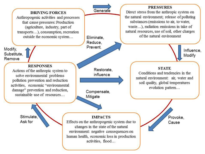 ) shows the basic elements of the DPSIR.
 |
Fig. (1) Elements of the DPSIR. |
Although there has been several criticisms against the DPSIR [8Bell S. DPSIR 1/4 a problem structuring method? an exploration from the “Imagine” approach. Eur J Oper Res 2012; 222: 350-60.
[http://dx.doi.org/10.1016/j.ejor.2012.04.029] , 9Karageorgis AP, Kapsimalis V, Kontogianni A, Skourtos M, Turner KR, Salomons W. Impact of 100-year human interventions on the deltaic coastal zone of the Inner Thermaikos Gulf (Greece): a DPSIR framework analysis. Environ Manage 2006; 38(2): 304-15.
[http://dx.doi.org/10.1007/s00267-004-0290-8] [PMID: 16779699] ] as a framework to analyse and understand pressure on the environment [10Gari SR, Newton A, Icely JD. A review of the application and evolution of the DPSIR framework with an emphasis on coastal social-ecological systems. Ocean Coast Manage 2014; 103: 63-77.
[http://dx.doi.org/10.1016/j.ocecoaman.2014.11.013] ], have argued that the framework is a veritable tool when focus is put on the links between the nodes of DPSIR by applying specific socio-economic and natural science-based models to understanding the cause-effect dynamics. This is more pertinent to peri-urban coastal environments with lagoon formation hydro-geomorphic systems, especially, for integrated management purpose [11Neves R, Baretta JW, Mateus M. The DSPIR frame work applied to the integrated management of coastal areas 2008.].
The sub-urban Lagoon coastal environment of Lagos, Nigeria, like any other marine environment is not immune to the problems of environmental pressures. Although largely residential oriented, rapid urbanization and commercialization have resulted in most wetlands and forested land being converted to built-up areas. This gradual invasion of rural areas by metropolitan zones (notion of continuum) constantly brings the status and very existence of rurality into play [12https://ec.europa.eu/energy/intelligent/projects/en/projects/ruraleevolution (Date visited; 22nd April, 2018)-14Frayssignes J. 2011. Special session: Territorial Governance, rural areas and local agro food systems The concept of “agro-energy district”: a pertinent tool for the sustainable development of rural areas. 51st Congress of the European Regional Science Association, Barcelona, 30th August – 3.]. Quantifying the rate of deforestation and identifying locations undergoing rapid change are key to understanding the driving forces and consequences for the Earth System [15Steffen W, Sanderson A, Tyson PD, et al. 2003. Global Change and the Earth System: a planet under pressure / IGBP Global Change Series, Springer-Verlag Berlin Heidelberg New York. ISSN 1619-2435, ISBN 3-540-40800-2.]. Also, solid waste garbage, coastal erosion, high turbidity, sediment loads and other physical alterations from increasing anthropogenic activities are continuously contributing to the pressure on the ecosystem. The land use conversion is accompanied by an intense pressure from the small to medium scale industries, sand mining activities, commercial activities, and transportation activities etc. Consequently, the environment is facing a serious pressure from anthropogenic activities, which have resulted in the reduction of qualitative traditional ecosystem services such as fish catch, recreation and water supply that the local people traditionally enjoy. Furthermore, coastal erosion and flooding have become the common phenomena causing environmental degradation. These have had great consequences on people’s health, occasioned by the contamination of drinking water and solid waste generation [16WHO. The World Health Report 2004. ISBN 92-4-156265-X., 17Vlahov D, Galea S. Urbanization, urbanicity, and health. J Urban Health 2002; 79(4)(Suppl. 1): S1-S12. [US National Library of Medicine, National Institutes of Health.].
[http://dx.doi.org/10.1093/jurban/79.suppl_1.S1] [PMID: 12473694] ] as well as inadequate water supply in the area [18Fantozzi F, Bartocci P, D’Alessandro B, Arampatzis S, Manos B. Public-private partnerships value in bioenergy projects: Economic feasibility analysis based on two case studies. Biomass Bioenergy 2014; 66: 387-97.
[http://dx.doi.org/10.1016/j.biombioe.2014.04.006] ]. proposed the adoption of the agroenergy district concept where rural areas host the production, transportation and the conversion of local biomass into energy as the way to reduce environmental pressure in the rural areas. Frayssignes, (2011) further argued that the agroenergy district approach to rural development can improve food security, local self-reliance, sustainable agricultural management, biodiversity conservation, climate change mitigation and improved energy supply and security. The benefit of the agroenergy district can be optimized through Public-Private Partnerships (PPPs) [19Manos B, Partalidou M, Fantozzi F, Arampatzis S, Papadopoulou O. Agro-energy districts contributing to environmental and social sustainability in rural areas: evaluation of a local public-private partnership scheme in Greece. Renew Sustain Energy Rev 2014; 29: 85-95.
[http://dx.doi.org/10.1016/j.rser.2013.08.080] ]. However, the land use trajectory of the study area can no longer support the production of sufficient feedstock for agroenergy district venture.
This study, therefore, examines the problems associated with environmental pressure by human footprint (anthropocene) along the Lagos lagoon coastal environment in the Ikorodu sub-urban settlement with a view to evaluate the historic trajectories of the land use change and analyse the drivers and pressures of the environmental degradation of the study area. The research hypothesis is formulated thus: “which factor is the most determining factor reducing the quality of the environment in the sub-urban lagoon coast of Ikorodu in Lagos, Nigeria”. This hypothesis will be determined by using driving force, pressure, state, impact and responses (DPSIR) analysis. Although the DPSIR analysis carried out in this study is limited by stakeholder influence [8Bell S. DPSIR 1/4 a problem structuring method? an exploration from the “Imagine” approach. Eur J Oper Res 2012; 222: 350-60.
[http://dx.doi.org/10.1016/j.ejor.2012.04.029] , 20Svarstad H, Petersen LK, Rothman D, Siepel H, Watzolde F. Discursive Biases of the Environmental Research Framework DPSIR. Land Use Policy 2008; 25(1): 116-25.
[http://dx.doi.org/10.1016/j.landusepol.2007.03.005] -22Olsson EGA. 2014.Environmental Stresses and Resource Uses Analysed by the DPSIR Framework In: Tran Dinh Lan, E. Gunilla Almered Olsson, Serin Alpokay (ed.), Environmental Stresses and Resource Use in Coastal Urban and Peri-Urban Regions DPSIR Approach to SECOA's 17 Case Studies. Cap. 10. SECOA FP7 Research Project, Vol. 7. Rome: Sapienza Università Editrice,
http://digilab-epub.uniroma1.it
[http://dx.doi.org/10.13133/978-88-98533-23-7.] ] and the cause-effect relationships approach of the framework between the latent variables factors (drivers, pressures, state, impacts and response) and their observed variables, these however, were dealt with by using robust environmental and socioeconomic dataset relating observed variables together to describe the state of the environment based on multiple pressures, that create multiple impacts [19Manos B, Partalidou M, Fantozzi F, Arampatzis S, Papadopoulou O. Agro-energy districts contributing to environmental and social sustainability in rural areas: evaluation of a local public-private partnership scheme in Greece. Renew Sustain Energy Rev 2014; 29: 85-95.
[http://dx.doi.org/10.1016/j.rser.2013.08.080] , 8Bell S. DPSIR 1/4 a problem structuring method? an exploration from the “Imagine” approach. Eur J Oper Res 2012; 222: 350-60.
[http://dx.doi.org/10.1016/j.ejor.2012.04.029] ] and responses
2. STUDY AREA
The study area extends from about latitude 60 37’ to 60 45’ and longitude 30 30’ to 30 5’. The total land cover is about 275.85 km2 with about 25% made up of lagoon. The major communities in the area includes; Ikorodu. Ipakodo, Ijede, Imota, Gbogbo and Ibeshe. Politically, the study area is within Ikorodu Local Government Area (LGA) of Lagos State. It physiographic features can be classified into mangrove and alluvial zones. The mangrove is made up of sands, which is unconsolidated and porous, while the alluvial zone is made up of low line and sandy tracts with silt and sand. The vegetation cover is deltaic swamps; made up of swamps and riparian forest as well as deciduous forest, found towards the northern edge. The area is characterised by short coastal plain, and numerous streams and tributaries of the Ogun and Osun rivers. Elevation ranges from about 2m along the lagoon coast to about 50m above the mean sea level (amsl) towards the northern end. The climate is humid tropics with dry and wet seasons. The wet season normally starts from the month of March and ends in October while the dry season comes up between November and February.
The occupations of the people include trading, farming and fishing. Other human activities in the area revolve around shopping complex, saw mill, brick and clay industry situated at Ibeshe and Igbogbo. Sand mining and other activities along its value chain of distribution are an important occupation that contributes significantly to the local economy of the area. The study area is accessible by both road and water (Lagos lagoon). In terms of development, however, the study area is a sub-urban or peri-urban area. In other words, it is a zone of transition from rural to urban land uses, located between the outer limits of the Lagos mega-city and the inland rural environment. The area encompasses both characteristics of the urban and rural world. As urbanization expands to the area in the last two decades, traditional activities are gradually declining while the green environment is being replaced by brown environment, placing pressures on the coastal Lagoon environment. Fig. (2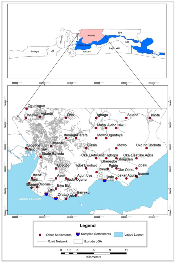 ) shows the location of the study area in Lagos State, Nigeria.
 |
Fig. (2) Ikorodu LGA in Lagos State. |
3. MATERIALS AND METHODS
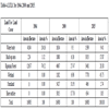
Fig. (3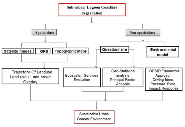 ) shows the methodological framework employed for this study while Table 1 shows the spatial data sources. Non-spatial data were acquired through questionnaire administration, field observation and In-depth Interview (Table 2). The survey research adopted is the systematic sampling technique applied in three selected communities along the lagoon; Oreta, Ijede and Offin. The communities were selected based on their location along the Lagoon coastline, spatial efficiency along the urbanized coast of the lagoon, high level of economic activities, natural resource exploitation and direct receptor of coastal degradation. The questions in the survey covers demographic characteristics of the respondents (including but not limited to age, sex and education background), socio-economic parameters (including but not limited to income and occupation), ecosystem services (including but not limited to fishing, sand mining and housing) and economic indices of selected ecosystem services (fishing and sand mining). As shown in Table 2, the social survey sampling technique adopted in choosing the number of respondents was predicated on population density (stratified sampling) of the selected communities while questionnaire administration in these communities was random.
 |
Fig. (3) Methodological framework. |
The sample size was complimented with Focus Group Discussion (FGD) and Key Informant Interviews to enrich and validate the quality of feedbacks from questionnaire. Communities that are the direct receptors of the degradation were specifically selected for questionnaire interview and the sample size chosen for these communities is sufficient and representative based on their population size.
4. LAND USE TRAJECTORIES MODELLING OF IKORODU LGA
Based on the knowledge of the researchers about the localities, reconnaissance survey, ancillary information from the 1964 topographic maps and additional information from key informants interview, a classification scheme after Odunuga et al (2011) hierarchical approach was developed for the land use interpretation. Five major classes were consequently identified at the primary level (level 1) while several classes were identified for each of the primary class at the secondary level (level 2). However, the mapping exercise was carried out at the primary levels due to the small area coverage of the study area. Table 3 shows the land use classification scheme. Area calculations of the land use / land cover (LU/LC) for the three scenarios (1964, 2000, and 2015) were carried out to determine the static land uses and land cover, analyse the direction of change (pressure) and determine the rate of change (impacts) on the biophysical resources of the environment. An overlay of the generated land use (1964-2015) was conducted. This provides information in matrix format on the specific point change detection procedure that generates the nature, location, and magnitude of changes [23Caeiro S, Mourao I, Costa MH, Painho M, Ramos TB, Sousa S. 2004.Application of the DPSIR model to the Sado Estuary in a GIS context Social and Economical Pressures. In: 7th AGILE Conference on Geographic Information Science 29 April-1May 2004, Heraklion, Greece Parallel Session 4.3- Environmental/Social Modelling, 13pp.].
5. DRIVING-FORCE, PRESSURE, STATE, IMPACT AND RESPONSE (DPSIR) ANALYSIS
A combination of the data generated from LULC and the questionnaire administration were modelled using the Factor Analysis (FA) to evaluate the state of the environment. The DPSIR approach was used in this analysis. Factor Analysis (FA) is a multivariate technique that integrates various variables of many drivers and pressures of the environment to establish their respective spatial relationship. The equation for the FA is given below:

Where: a = no of variables, f = factor loadings which is constant, Y= variable with a known data and e1 is error term.
Data were collected on relevant variables that cut across human population, socio-economic indices infrastructures development, human activities including small and medium scale industrial activities, extractive processes, land use, biodiversity issues and policy issues. Overall, forty five (45) variables were related together under the latent factors of; drivers, pressure, state, impact and response. The ‘drivers’ were defined as the underlying factors causing a variety of change. The ‘pressures’ are the variables that directly caused the changes in the initial wetland environment. The ‘state’ is a measure of the present physical conditions of the wetlands ecosystem; it identifies the current status and impacts resulting from these pressures. The ‘impacts’ describes the effect of changes especially as they affect the ecosystem services of the wetlands while the ‘response’ is defined as the measures devised by the stakeholders to proffer solution to the problems resulting from the changes in the ecosystem function. It includes the policies, plans or projects taken by the government to reduce the pressures and their negative impacts on the environment and the people. For each of the latent factors (DPSIR), the initial variables were extracted from the pool of observed variables using principal components by linear combination with maximum variance. The percentage (%) variability of the components was adopted in choosing the number of variables to retain for each of the latent factors while Orthogonal varimax approach (maximize squared loading variance across variables: sum over factors) (equation 1) was adopted in the FA rotation. Interpretation with orthogonal is simple because factors are independent while loadings are correlations. However, variables with positive PFA (Principal Factor Analysis) values close to 1 are considered as having significant but positive relationship with the environment. Variables with negative values close to 1 are considered as having significant but negative relationship with the environment. Significant in this context is the level of correlation depicted by the regression coefficients of PFA value.
The flowchart for the DPSIR-factor analysis used for this study is shown in Fig. (4 ) and it has five major observed variables; (1) identifying and interpreting the drivers; (2) interpreting the pressures; (3) describing the state changes; (4) describing the impacts; and (5) reviewing the human response. The latent variables (factors) that exert causal influence on these observed variables are shown in the corresponding right side of Fig. (4). Drivers were derived from the population dynamics, the socioeconomic trends and the associated anthropogenic activities that have taken place over the previous years through land use change analysis (rate and trend). The factors that exert pressure that are considered include road development, industrial activities, fishing and sand mining. The state was described in terms of physical and biological wellness of the environment. The impacts considered were assessment of changes in the ecosystem services (ecological impacts) and socioeconomic impacts. The responses were extracted from the on-going policy implementations of both the Local and State governments. Fig. (4) shows the flowchart defining the DPSIR-FA latent variables and their major components.
 |
Fig. (4) Flowchart for the DPSIR PFA. |
6. ECONOMIC VALUATION OF SELECTED ECOSYSTEM SERVICES
A comprehensive assessment of land uses was linked to a systematic environmental and economic analysis of the benefits they generate [24Odunuga S, Omojola A, Oyebande L. Urban land use dynamics of system 6c watershed, Lagos, Nigeria, Lagos Jour. of Geo-. Inf Sci 2011; 1(1): 7-18.] by evaluating the economic benefits and services of fishing and artisanal sand mining in the lagoon and surrounding wetlands. The economic valuation of these ecosystem services was based on Direct Use Method (DUM) using the Market-Price Based approach. This approach estimates the economic value for ecosystem products and services that are bought and sold in commercial markets [25Bateman IJ, Harwood AR, Mace GM, et al. Bringing ecosystem services into economic decision-making: land use in the United Kingdom. Science 2013; 341(6141): 45-50.
[http://dx.doi.org/10.1126/science.1234379] [PMID: 23828934] ]. This, in other words, shows how these respond to the forces of demand and supply. The actual service produced by each of the chosen services (fishing and artisanal sand mining) was based on the annual income generated by the producers (Fishermen and sand mining merchants). The income (producer surplus) is calculated as the difference between the total revenues earned from the goods (fish and sand), and the total cost of production. This was calculated per kilogram (kg) for fish and per ton for sand in each of the three sampled locations (Oreta, Ijede and Offin). The average income (I) for the ecosystem service was the average derived from respondents (Table 2) in each of the locations.
Equation 2 describes the economic benefit from the ecosystem services of the environment.

y = annual income derived from ecosystem for particular services by location
n = number of tons or kg derived in a year
I = average income per ton or kg.
The classification scheme used in the remote sensing technique and the socio-economics survey captured all underline factors (Natural and Socio-economics) that could contribute to environmental degradation of the study area. No environmental and socio-economic variable was ignored or over-weighted in its contribution to the problem under investigation. Therefore, the principal factors calculated in each component of the five DPSIR variables are reliable and reveal the situation in the study area.
7. RESULTS AND DISCUSSIONS
7.1. Static Urban Land Use / Land Cover Distribution
Table 4 shows the static LULC over the three year scenarios (1964, 2000 and 2015) in the study area while Figs. (5 and 6
and 6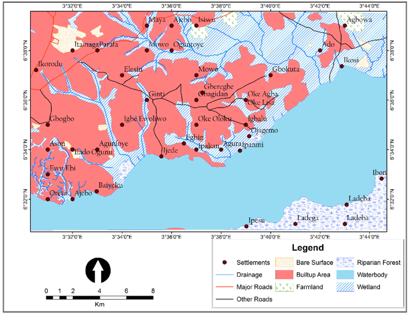 ) show the spatial distribution of LULC for 1964, and 2015 scenarios respectively.
Riparian forest was the dominant land cover in 1964 and occupied about 74.52% of the study area. In fact, all areas that were latter exposed and regarded as wetland by year 2000 were actually under riparian forest as at 1964. The presence of a large expanse of forested land at this period (1964) can be attributed to less socio-economic activity, low productivities, dominance of primary activities and low population. Socio-economic activities were traditional, while hunting and subsistence farming where the major occupations at this period. This agrees with [14Frayssignes J. 2011. Special session: Territorial Governance, rural areas and local agro food systems The concept of “agro-energy district”: a pertinent tool for the sustainable development of rural areas. 51st Congress of the European Regional Science Association, Barcelona, 30th August – 3.] which describes earlier settlers of most parts of the globe as hunter-gatherers who had few advantages in the hunt, other than their social organisation and technological inventiveness. However, the riparian forest decreased from 12657 ha in 1964 at an average annual rate of 170.30 ha to 3461 ha in 2015 while the built up area increased to about 1,080 ha (17.87%) in 2015 from 224 ha (1.32%) in 1964 with an average annual growth rate of 16.78ha per annum. This trend agrees with [26UNEP. Ecosystem Services Economics (ESE) Working Paper Series (No 8), Valuation of Ecosystem Services in Coastal Ecosystems: Asian and European Perspective, UNEP Division of Environmental Policy Implementation.2011.] which identifies a decreasing trend in the wetland changes in the sub-urban areas of Lagos and attributed the decreases to urban development pressures. Fig. (4) depicts the spatial distribution of the land use/ land cover in 2015. Also, the emergence of the wetland ecosystem from the riparian forest in the 80s and 90s as a result of the removal of the canopy forest is a manifestation of a sustained increase in human activities and the utilization of the forest resources with little or no effort to replace the destroyed trees. By 2015, the wetland ecosystems occupied about 7770 ha (45.75%) of the study area acquiring its total area extent from the riparian forest losses. Further developmental activities are also putting pressure on the wetlands [23Caeiro S, Mourao I, Costa MH, Painho M, Ramos TB, Sousa S. 2004.Application of the DPSIR model to the Sado Estuary in a GIS context Social and Economical Pressures. In: 7th AGILE Conference on Geographic Information Science 29 April-1May 2004, Heraklion, Greece Parallel Session 4.3- Environmental/Social Modelling, 13pp.].
 |
Fig. (5) Land use/land cover Distribution (1964). |
 |
Fig. (6) Land Use / Land Cover Distribution (2015). |
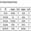
Fig. (7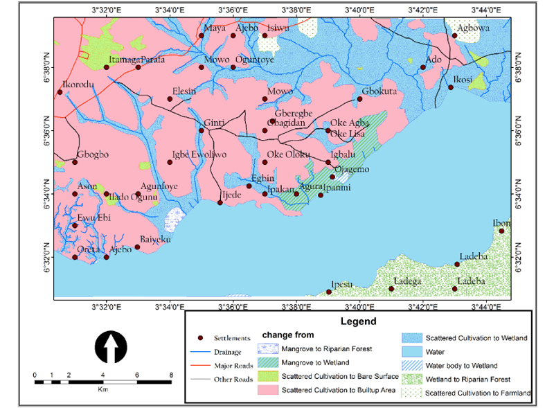 ) is an overlay map showing the specific location of change of land cover in the study area. Table 5 describes the nature of the land use and land cover change for 1964-2015. The figures, along the diagonals of the table, represent the areas where no change has taken place, thus showing the relative stability of those classes. Figures along the rows (excluding those along the diagonal) represent losses to land use / land cover classes (Pressure; housing, roads, industries and wetland conversion) and those along the columns are gains to land use / land cover (state; resource exploitation and land degradation) and (Impact; water pollution and flooding). Overall, the direction of land cover change in the study area shows a reduction in the forest cover. However, deforestation, land cover and land use changes have been identified to have negatively impacted the ecosystem’s services to the human community, thus threatening food, water, and energy security [27Obiefuna JN, Nwilo PC, Atagbaza AO, Okolie CJ. Spatial Changes in the Wetlands of Lagos/Lekki Lagoons of Lagos, Nigeria J Sustain Dev 6(7): 123-33. ISSN 1913-9063 E-ISSN 1913-9071. doi:10.5539/jsd.v6n7p123 URL: http://dx.doi.org/10.5539/jsd.v6n7p123.-31Ayeni AO, Cho MA, Mathiew R, Adegoke JO. The local expert’ perception of environmental change and its impacts on surface water in Southwestern Nigeria. Environ Dev 2016; 17: 33-47.
[http://dx.doi.org/10.1016/j.envdev.2015.09.007] ]
 |
Fig. (7) Overlay Land use/Land cover distribution (1964 - 2015). |
8. ENVIRONMENTAL DEGRADATION USING DPSIR ANALYSIS
8.1. Drivers of Change in the Environment
Table 6 shows that rapid growth of human population and economic development are significant drivers of change in the sub-urban Lagoon Coastal environment of Ikorodu, Lagos. Human population and economic activities also significantly have stronger influence among other variables with PFA values of 0.693 and 0.542 (component 1) respectively. The PFA is like the standardized regression coefficients, therefore, the variables, human population and economic activities have a correlation of 0.69 and 0.54 respectively. They are, however, considered to have a strong positive association with environmental degradation under driving force factor. The values also suggest that the human population variable has more impact as a driving force in causing degradation than the economic activities in the sub urban lagoon coastal environment of Ikorodu in Lagos.
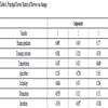
As human population increased, human needs, demand as well as supply increased, thereby encouraging a faster growth of economic activities within the area. With the increasing levels of anthropogenic activities, therefore, other subsistence based economic developments were giving way to increased commercialization while the rates of in-migration were accelerating. For instance, the population growth rate of Ikorodu LGA between 1991 and 2006 was put at 4.33% per annum with a population density of 7,207 persons/km2 in 2006 [32Ogutu JO, Piepho H, Said MY, Kifugo SC. Herbivore Dynamics and range Contraction in Kajiado County Kenya: Climate and Land Use Changes, Population Pressure, Governance, Policy and Human-Wildlife Conflict. Open Ecol J 2014; 7: 9-31.
[http://dx.doi.org/10.2174/1874213001407010009] ]. However, the estimated population growth rate of the same LGA between 2006 and 2015 was put at 8.84% per annum [33National Population Commission of Nigeria. 2006. The population of Local government areas (LGAs) of metropolitan Lagos (2006), Retrieved from
www.citypopulation.de/Nigeria-Lagos.html]. This has led to a rapid urbanization, an increase in built up areas as shown in Table 4 and general loss of riparian forest. Expectedly, all of this has contributed to have negative impacts on the environment [34National Population Commission of Nigeria. 2016. The population of Ikorodu Local government areas in 2016, Retrieved from http://population.city/nigeria/ikorodu/] as they led to changes in landscape patterns, ecosystem functions and their capacity to perform various functions in support of increasing human populations [27Obiefuna JN, Nwilo PC, Atagbaza AO, Okolie CJ. Spatial Changes in the Wetlands of Lagos/Lekki Lagoons of Lagos, Nigeria J Sustain Dev 6(7): 123-33. ISSN 1913-9063 E-ISSN 1913-9071. doi:10.5539/jsd.v6n7p123 URL: http://dx.doi.org/10.5539/jsd.v6n7p123.].
Similarly, transportation, technology and urbanization revealed strong negative parameter with PFA value of -0.649 (component 3), -0.614 and -0.533(component 1) respectively. This implies that the variables are important drivers of change in the study area, but are, however, latent and passive players as drivers of the environmental change.
8.2. Pressures on the Environment
Increase in human population and economic activities increased the need for fishing, small scale industries and sand mining activities. These are significant activities that currently exert pressures on the sub urban coastal environment of Lagos. Indeed, they exhibit strong and significant PFA values of 0.950, 0.894 and 0.767 (Component 1) respectively as shown in Table 5. Population growth exerts greater pressure on the natural resource utilization, production and consumption pattern in many ways. As people settled along the sub-urban Lagoon Coast, the need for the exploitation of the available coastal resources became imperative. Sand mining and fishing became the major occupation of the people who had little or no idea about its consequences to both the resource and the environment [35Department of Environment and Resource Management (DERM). 2011. submissions for Minister for Natural Resources, Mines and Energy and Minister for Trade, for State of Queensland.]. The need for transportation necessitated the need for road construction and expansion as exemplified by a PFA value of 0.760 (Component 2) for road (Table 7). Consequently, road construction has significantly altered the landscape as more land have been consumed for road expansion. It has also served as a source of air pollution, increased runoff, reduced infiltration and contributed in several other ways to exert pressure on the fragile coastal ecosystem. More crucial is that, fishing activities have a strong positive PFA value of 0.95 and therefore, exert the greatest active pressure on the sub-urban Lagoon Coastal resources in the study area. This is in line with the findings of [36UN-Habitat. 2010.Expert Workshop 16 - 17 November, 2009; Naivasha, Kenya. Kenya: Wildlofe Training Institute 2010.], which revealed that there has been a decline in the quantity of different species of fish caught over the years in the System I Drainage Area of Lagos which is connected to the Lagos lagoon through Ogudu Creeks.
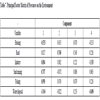
Among the parameters evaluated, floating houses have strong negative PFA value of -0.706. This constitutes the most significant latent and passive variable exerting pressure and causing the degradation of the sub urban lagoon coast of Ikorodu in Lagos. Other parameters have very little influence in exerting pressure on the environment.
8.3. State of the Environment
The present state of the sub-urban Lagoon Coast of Ikorodu in Lagos is dominated by resource exploitation as exemplified in sand mining, fishing and conversion of riparian forest / wetlands to built-up area for residential and other purposes. Table 8 shows resource exploitation with a strong positive PFA value of 0.735 (Component 1). Land degradation also shows a strong negative PFA value of -0.714, indicating a negative and much degraded environment that is battling with many environmental challenges such as flooding and erosion, poor drainage, bad roads and generally low quality unplanned environment.
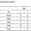
Overfishing and excessive fishing have the potential to modify the ecosystem and may alter or affect the target source, species composition and biodiversity [36UN-Habitat. 2010.Expert Workshop 16 - 17 November, 2009; Naivasha, Kenya. Kenya: Wildlofe Training Institute 2010.]. This may further lead to a progressive reduction in the food chain owing to a reduction in the biomass of fishery below the desired levels of maximum sustainability or economic yields. Also, the biotic integrity of the aquatic ecosystem within the wetlands and the lagoon is regrettably being threatened by different anthropogenic activities, especially by domestic waste and sewage from the densely populated lagoon coastal environment. Artisanal sand mining occurs concurrently with fishing in the area and this further constituted a major disturbance to the biotic integrity of the lagoon and the wetlands. Thus, the negative impact of sand mining far outweighs the economics and environmental benefits. When sand are removed with or without using heavy machinery, erosion capacity increases and this might constitute a further environmental threat; a situation which is already manifesting in the study area. Other variables like land degradation shows a strong negative relationship with PFA value of -0.714. Global warming exhibits a positive PFA value at component 2, which reveals some level of temperature response to losses, recorded in vegetation cover over the last 50 years. But this is not as strong as expected probably owing to the cooling effect of the lagoon and other water bodies. In conclusion, using PFA, the DPSIR analysis shows that resource exploitation is the most significant activity exacerbating the current state of the sub-urban Lagoon Coast of Ikorodu in Lagos. The resources being exploited include; fish, sand and forest resources.
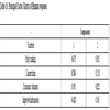
8.4. Impacts on the Environment
The significant environmental impacts on the study area include bank erosion (PFA value of 0.715 at component 1) which has been accelerated by sand mining, biodiversity loss (PFA value of 0.760 at component 1) which has also been on the increase through deforestation and indiscriminate/uncontrolled fishing in the lagoon. Generally, the results show that environmental change has manifested in many ways, and as already identified, has led to frequent extreme flooding incidents (PFA value of 0.626 at component 2), damage to goods and properties especially by flood and losses to both tangible and intangible human values, including loss of valuable times [37Adegun O, Odunuga S, Appia Y. Dynamics in the Landscape and Ecological Services in System I Drainage Area of Lagos. Ghana Journal of Geography 2015; 7(1): 75-96.]. Table 9 shows the matrix for the PFA values of impacts on the environment.

Also, the frequency of flood (coastal, river and flash) has been on the increase even though the losses from annual flood events are yet to be estimated. Health hazard, as exemplified in lack of health facilities to cater for the growing population, have become challenges in the area. Besides, pollution of the environment, especially the coastal water, indiscriminate dump of waste in the lagoon have caused damages to the environment. The results show that health hazard has PFA of 0.833 (Table 9) and therefore, posed a great risk to the increasing population of the sub-urban Lagoon Coast of Ikorodu in Lagos.
8.5. Response of Human Society to the Environmental Changes
The result from the analysis of human response to the environmental changes (Table 10) shows that the responses to various environmental pressure and threats have not been proactive and well-coordinated to eliminate the negative consequences and maximize the benefits in a sustainable way. For instance, the result of the overlay analysis on the LU/LC shows an increase in the urban trends with increase in population. Consequently, how the study area is governed and what provisions are made to serve the expanding population have very significant implications for economic and social development, and also for environmental quality and stability [38Odunuga S, Oyebande L, Omojola AS. Social economic indicators and public perception on urban flooding in Lagos 2012; 82-96.]. Although policy making has a medium positive correlation value, the implementation of policy output has been very weak.
There is a link between this and community perception of the situation. Members of the community assumed that there is need for local regulations to guide the affairs of the population in the community. However, there are state agencies that control theses affairs presently and they include the Lagos State Waste Management Authority, the Lagos State Environmental Protection Agency, the Lagos Sate Water Corporation and the Federal Erosion and Flood Control Policy. Several regulations have also been put in place by the Local Government Authority, to cater for the environment, especially the coastal environment. These bodies / agencies are established to reduce conflicts and increase the socio-economic benefits obtained from the ecosystem services while also sustaining the resource base and ecosystem functions. However, enforcement and implementation of the regulations and guidelines have been the major challenge for these agencies. For instance, the federal and state governments that have the capacity for real time enforcement are too far away from the local people while their presence is mostly felt in the state capitals. Also, the suburb and the interior rural areas are often neglected in the implementation of programmes and dissemination of information. The poor service delivery on the part of the government can be redressed through the strengthening of civil society and Non-Governmental Organisations (NGOs). In Nigeria, the civil society and non-governmental organisations activities have been found to be effective [39Satterthwaite D. Urbanization in low – and middle – income nations.The Companion to development studies 2008; 237-43.]. They are highly flexible and have access to the people at the grass-roots level. In addition, their sustained advocacy has made governments to address critical needs and gaps in the environment, health, education and other sectors. However, they should act as strategic partners for reforms and result-oriented government agencies to eliminate the negative consequences of sub-urban coastal development while maximizing the benefits of sustainable development and coastal ecosystem services.
9. ECOSYSTEM SERVICES
9.1. Fish Catch Valuation
An ecosystem assessment on fishing as a major ecosystem service of the lagoon and the wetlands shows that the income accruable to the individual fisherman varies by location along the coastline (Table 11). It also shows that the average annual income derived from fishing per fisherman between 2010 and 2014 is about $1521.68. Although, fishery in the area has been evolving upwards as new members of fishermen continued to join in recent years, declining fish catches have also been reported. This agrees with the results of the DPSIR under pressure with PFA value 0.950 fishing. This shows that fishing activity is one of the activities exerting pressure on the sub-urban Lagoon Coastal ecosystem of Lagos. The implication of this is that the resource exploitation from the wetlands and lagoon formations of the sub-urban environments of Lagos especially in Ikorodu in terms of fishery is higher than the replenishment rate. If this continues, the fishermen will soon be out of business and this may create serious socio-economic crisis for this group. To mitigate this potential problem, there is a need for an urgent re-orientation and retraining of the fishermen to engage in fish farming, utilizing the comparative advantages of the wetlands. This will increase the income of the local fishermen as well as enhance their capacity without necessarily changing their trade. Although, aquaculture is well known to be a contributor to the increasing level of organic waste and toxic compounds in the environment causing considerable economic loss [40http://worldwideaquaculture.com/aquaculture-and-fish-farming-impacts-on-environment/ (Date visited; 6th April, 2017)], its problems can be addressed using the appropriate waste treatment processes based on the site [41Utuk IO. The Role of Non-Governmental Organizations (NGOs) In Participatory and Sustainable Rural Economic Development in Nigeria. J Econ Finance 2014; 4(1): 22-30. [JEF].]. However, the environmental deteriorating impact of fish farming, including toxic effluent from fish ponds, will have to be addressed through an integrated aquaculture system [41Utuk IO. The Role of Non-Governmental Organizations (NGOs) In Participatory and Sustainable Rural Economic Development in Nigeria. J Econ Finance 2014; 4(1): 22-30. [JEF].] and zero waste approach where the Biomaterial from fish farms can be periodically dredged and used as fertilizer in the production of local crops before they become heavily toxic. Also the fish waste can be converted to poultry feeds while the poultry drops in turn can be converted to fish feeds. For instance [41Utuk IO. The Role of Non-Governmental Organizations (NGOs) In Participatory and Sustainable Rural Economic Development in Nigeria. J Econ Finance 2014; 4(1): 22-30. [JEF].-43https://coastalscience.noaa.gov/news/ecosystem-management/fish-farming-improvements-reduce-environmental-impacts-of-aquaculture/2017.], have noted that by integrating fed mariculture (fish and shrimp) with inorganic and organic extractive mariculture (seaweed and filter feeding bivalve), the wastes of one resource consumer could become a resource (fertilizer or food) for others in the system. Such a balanced ecosystem approach would provide the nutrient bioremediation capacity, mutual benefits to co-cultured organisms, and economic diversification by producing other value-added profitable products [42Cao L, Wang W, Yang Y, et al. Environmental impact of aquaculture and countermeasures to aquaculture pollution in China. Environ Sci Pollut Res Int 2007; 14(7): 452-62.
[http://dx.doi.org/10.1065/espr2007.05.426] [PMID: 18062476] ].
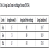
9.2. Sand Mining Evaluation
Sand mining contributes significantly to the micro-economies of the study area and its immediate environment. During the period evaluated, the average annual sand mining contribution to direct cash flow was about $ 68,489.47 for Ijede, $17447.37 for Oreta and $ 4926.32 for Offin (Table 12). These indeed are significant but the bulk of the income goes to individual hands along the value chain from the extraction to utilization stage. Those involved in the activities hardly pay the value added taxes on the product and services they render and if at all they pay, the taxes are not properly valued. These thus, agree with the results of the DPSIR under response of human society to the environmental changes, which identifies a weak implementation of policy output. Also, as identified under pressures analysis of the DPSIR, sand mining recorded a PFA value of 0.767 (component 1) indicating a variable that exert great pressure, thereby, contributing significantly to the degradation of the sub-urban lagoon coastal environment of Lagos. The impacts of this activity as exemplified through an impact analysis of DPSIR, includes amongst others; bank erosion with a PFA value of 0.715 (component 1) and biodiversity loss with a PFA value of 0.760 (component 1). The overall analysis of the artisanal sand mining activities along the sub-urban communities of Lagos lagoon system reveals that, the activity derives much benefit from the lagoon ecosystem [44Chopin T, Buschmann AH, Halling C, et al. Integrating seaweeds into aquaculture systems: A key towards sustainability. J Phycol 2001; 37: 975-86.
[http://dx.doi.org/10.1046/j.1529-8817.2001.01137.x] ].

9.3. Integrated Assessment of the Environmental Changes
Based on the earlier analysis of the environmental changes from human drivers, pressures, state, impacts and human responses, a set of comprehensive indicators were deduced for the integrated DPIRS assessment. The indicators encompass two driver indicators, four pressure indicators, two state indicators, eight impact indicators and two response indicators (Fig. 8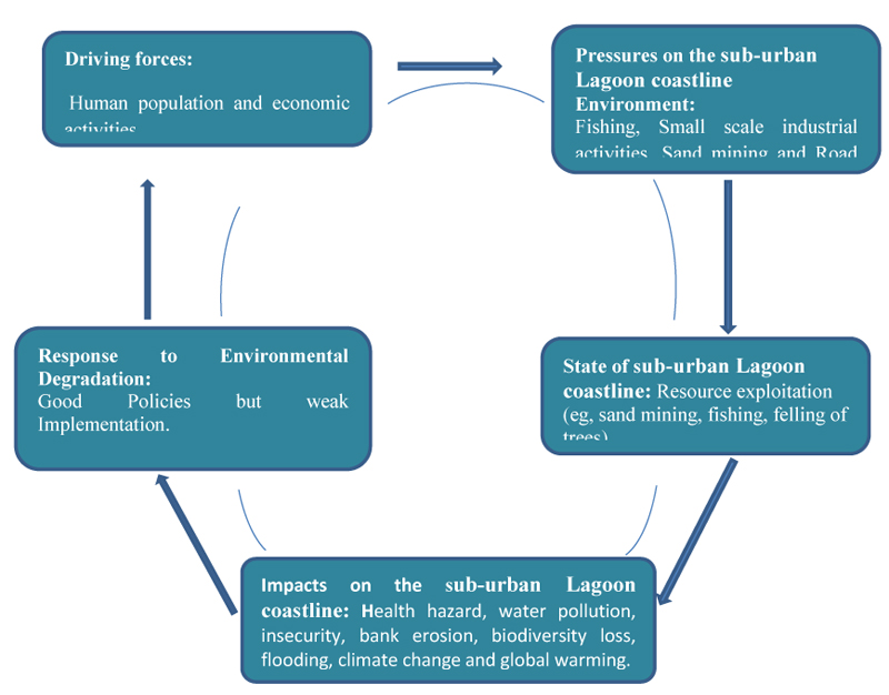 ).
).
 |
Fig. (8) DPSIR Assessment of sub-urban Lagoon coastline of Lagos, Nigeria. |
The pressures indicators express the external disturbances to the environment and ecosystem, and the larger they are, the more harmful their influence and impact on the state of the environment [45Lin T, Xue X-Z, Lu C-Y. Analysis of Coastal Wetland Changes Using the “DPSIR” Model: A Case Study in Xiamen, China. Coast Manage 2007; 35
[http://dx.doi.org/10.1080/08920750601169592] ]. On the contrary, the responses indicators express the positive feedback from human society, and the larger they are, the better the influence and impact on the state of the environment [45Lin T, Xue X-Z, Lu C-Y. Analysis of Coastal Wetland Changes Using the “DPSIR” Model: A Case Study in Xiamen, China. Coast Manage 2007; 35
[http://dx.doi.org/10.1080/08920750601169592] ]. It can be concluded therefore, that between 1964 and 2015 the drivers of degradation in the study area which include human population growth and developmental activities have increased over time. Fisheries, sand mining and small scale industrial activities including block making and bakery have directly caused the changes in the environmental state of the study area in terms of resource exploitation and land degradation. Furthermore, they have led to both negative and positive impacts; where the negative impacts on the socio-economic and environmental aesthetics of the communities include water pollution, flooding, and bank erosion etc.
Specifically, the period between 1980 and 2015 witnessed a high population growth rate, rapid increase in housing stock and unprecedented urban sprawl with little or no planning control. These growths, however, reflects Nigeria’s economic growth, as seen in the nation’s Gross Domestic Product (GDP) which increased from an average of 100 billion USD in the 90s to 568.5 billion USD in 2014. It is also interesting to note that the period between 1999 and 2015 witnessed political stability in the country. The economic growth and political stability have jointly contributed to the rapid growth in the urban and sub-urban environments of the country. However, the consequences of weak implementation of policies and programmes identified by the DPSIR analysis in this study are signified by a degraded sub-urban lagoon coastal environment where flooding, coastal erosion, reduced ecosystem services and continuous exploitation of the coastal resources are the order of the day. On the whole, the state of the environment, with special reference to the sub-urban lagoon coastal systems of Lagos, is getting worse owing to the uncoordinated developmental activities and unrestricted resource exploitations. Although, some efforts to reverse the situation through the provision of infrastructures such as the modern jetty at Ebute-Ikorodu and the construction of inner roads have been put in place, these have not however, yielded the needed results that could transform the fragile lagoon coastal environment of Ikorodu in Lagos into a global classical waterfront area.
On the most determining factor reducing the quality of environment in the sub-urban lagoon coast of Ikorodu in Lagos, Nigeria, as stated by the working hypothesis, Table 13 shows the significant factors which determine the quality of the environment based on each segment of DPIRS assessment.
CONCLUSION
The trajectories of land use change in the sub urban lagoon coastal environment of Ikorodu in Lagos using remote sensing technique shows a steady and continuous decrease in the riparian forest. This decrease owes largely to urbanization, forest resource exploitation and other human developmental activities. Also, the emergence and decreasing trend in wetland resources [23Caeiro S, Mourao I, Costa MH, Painho M, Ramos TB, Sousa S. 2004.Application of the DPSIR model to the Sado Estuary in a GIS context Social and Economical Pressures. In: 7th AGILE Conference on Geographic Information Science 29 April-1May 2004, Heraklion, Greece Parallel Session 4.3- Environmental/Social Modelling, 13pp.]. have created additional pressures on the area causing environmental degradation and reducing ecosystem services of the coastal environment. Drivers, Pressures, State, Impact and Response Indicators showed that pressures from human population and economic development have increased over time [44Chopin T, Buschmann AH, Halling C, et al. Integrating seaweeds into aquaculture systems: A key towards sustainability. J Phycol 2001; 37: 975-86.
[http://dx.doi.org/10.1046/j.1529-8817.2001.01137.x] ]. and as demonstrated in the land use analysis in this study, the continuous loss of the critical components of the environment such as the forest is a steady one. Resource exploitation, waste and water pollution have directly caused the degradation of the environment in both physical and biological aspects, which have consequently led to much negative ecological and socio economic impacts. Also, pressure from fishing and housing including floating houses have also caused serious damages to environment and the ecosystem. However, urbanization, deforestation, fishing, sand mining, transportation, housing, resources exploitation and land degradation have direct strong association with population. Consequently, the most determining factor reducing the quality of the environment in the sub-urban lagoon coast of Ikorodu in Lagos, Nigeria is the human population, which is on the increase in the study area. However, serious human effort to protect the environment through policy formulations amongst which include the continuous updating of the regional master plan of Lagos State have not yielded positive results. Consequent upon this, continuous data collection, analysis, interpretation and updating of data concerning environmental issues in the sub-urban lagoon coastal areas are required to curtail the possibility of the area transforming into a despicable city slum. Public awareness campaign about the environmental degradation issues identified in this study should be encouraged while strengthening the implementation of existing policies. Local communities should be involved in the planning and management of intervention projects so as to reduce resource exploitation, safeguard coastal areas and human well-being. All these, will ensure a sustainable sub-urban lagoon coastal environment of Lagos.
CONSENT FOR PUBLICATION
The Author has given the consent for his paper to be published by Open Environmental Sciences.
CONFLICT OF INTEREST
The authors declare no conflict of interest, financial or otherwise.
ACKNOWLEDGEMENTS
Decleared none.
REFERENCES
| [1] | Kremer H, Crossland C. Coastal change and the “Anthropocene”: Past and future perspectives of the IGBP-LOICZ project. In: Deutsches Nationalkomitee fur das Internationale Hydrologische Programm (IHP) der UNESCO und das Operationelle Hydrologische program (OHP) der WMO, Herausgeber, Koblenz, Germany; IHP/OHP Berichte, Sonderheft 13, 2002. |
| [2] | Creel L. Ripple Effects: Population and Coastal Regions. Making the Link: Population Reference Bureau, 2003, 8. |
| [3] | ACOPS - Advisory Committee on Protection of the Sea. Nigeria National Report: Phase 1: Integrated Problem Analysis Authored by Awosika, L, Osuntogun, N, Oyewo, E and Awobamise, A for the Global Environment Facility project Development and Protection of the Coastal and Marine Environment in Sub-Saharan Africa (GF/6010-0016), jointly undertaken with UNESCO-IOC 2002. e |
| [4] | Agboola J I, Odunuga S. Coastal Watershed Ecosystem Services Management in West Africa: Case of Ghana and Nigeria. Ecosystem Services and River Basin Ecohydrology, Springer 2015; 251-274. |
| [5] | Kjerfve B. Coastal Lagoon Elsevier Oceanography series, 60 1994. |
| [6] | Jago-on KA, Kaneko S, Fujikura R, et al. Urbanization and subsurface environmental issues: an attempt at DPSIR model application in Asian cities. Sci Total Environ 2009; 407(9): 3089-104. [http://dx.doi.org/10.1016/j.scitotenv.2008.08.004] [PMID: 18922564] |
| [7] | Lan TD. Conclusions: Environmental pressures and conflicts in urban and periurban regions, In: Tran Dinh Lan, E. Gunilla Almered Olsson, Serin Alpokay (ed.), Environmental Stresses and Resource Use in Coastal Urban and Peri-Urban Regions DPSIR Approach to SECOA's 17 Case Studies. Cap. 10. SECOA FP7 Research Project, Rome: Sapienza Università Editrice, 2014; 7: 385-394.
http://digilab-epub.uniroma1.it [http://dx.doi.org/10.13133/978-88-98533-23-7] |
| [8] | Bell S. DPSIR 1/4 a problem structuring method? an exploration from the “Imagine” approach. Eur J Oper Res 2012; 222: 350-60. [http://dx.doi.org/10.1016/j.ejor.2012.04.029] |
| [9] | Karageorgis AP, Kapsimalis V, Kontogianni A, Skourtos M, Turner KR, Salomons W. Impact of 100-year human interventions on the deltaic coastal zone of the Inner Thermaikos Gulf (Greece): a DPSIR framework analysis. Environ Manage 2006; 38(2): 304-15. [http://dx.doi.org/10.1007/s00267-004-0290-8] [PMID: 16779699] |
| [10] | Gari SR, Newton A, Icely JD. A review of the application and evolution of the DPSIR framework with an emphasis on coastal social-ecological systems. Ocean Coast Manage 2014; 103: 63-77. [http://dx.doi.org/10.1016/j.ocecoaman.2014.11.013] |
| [11] | Neves R, Baretta JW, Mateus M. The DSPIR frame work applied to the integrated management of coastal areas 2008. |
| [12] | https://ec.europa.eu/energy/intelligent/projects/en/projects/ruraleevolution (Date visited; 22nd April, 2018) |
| [13] | https://ec.europa.eu/energy/intelligent/projects/sites/ieeprojects/files/projects/documents/rurale.evolution_publishable_final_report_en.pdf (Date visited; 22nd April, 2018) |
| [14] | Frayssignes J. 2011. Special session: Territorial Governance, rural areas and local agro food systems The concept of “agro-energy district”: a pertinent tool for the sustainable development of rural areas. 51st Congress of the European Regional Science Association, Barcelona, 30th August – 3. |
| [15] | Steffen W, Sanderson A, Tyson PD, et al. 2003. Global Change and the Earth System: a planet under pressure / IGBP Global Change Series, Springer-Verlag Berlin Heidelberg New York. ISSN 1619-2435, ISBN 3-540-40800-2. |
| [16] | WHO. The World Health Report 2004. ISBN 92-4-156265-X. |
| [17] | Vlahov D, Galea S. Urbanization, urbanicity, and health. J Urban Health 2002; 79(4)(Suppl. 1): S1-S12. [US National Library of Medicine, National Institutes of Health.]. [http://dx.doi.org/10.1093/jurban/79.suppl_1.S1] [PMID: 12473694] |
| [18] | Fantozzi F, Bartocci P, D’Alessandro B, Arampatzis S, Manos B. Public-private partnerships value in bioenergy projects: Economic feasibility analysis based on two case studies. Biomass Bioenergy 2014; 66: 387-97. [http://dx.doi.org/10.1016/j.biombioe.2014.04.006] |
| [19] | Manos B, Partalidou M, Fantozzi F, Arampatzis S, Papadopoulou O. Agro-energy districts contributing to environmental and social sustainability in rural areas: evaluation of a local public-private partnership scheme in Greece. Renew Sustain Energy Rev 2014; 29: 85-95. [http://dx.doi.org/10.1016/j.rser.2013.08.080] |
| [20] | Svarstad H, Petersen LK, Rothman D, Siepel H, Watzolde F. Discursive Biases of the Environmental Research Framework DPSIR. Land Use Policy 2008; 25(1): 116-25. [http://dx.doi.org/10.1016/j.landusepol.2007.03.005] |
| [21] | Levrel H, Kerbiriou C, Couvet D, Weber J. OECD pressure-state-response indicators for managing biodiversity: a realistic perspective for a French biosphere reserve. Biodivers Conserv 2009; 18(7): 1719-32. [http://dx.doi.org/10.1007/s10531-008-9507-0] |
| [22] | Olsson EGA. 2014.Environmental Stresses and Resource Uses Analysed by the DPSIR Framework In: Tran Dinh Lan, E. Gunilla Almered Olsson, Serin Alpokay (ed.), Environmental Stresses and Resource Use in Coastal Urban and Peri-Urban Regions DPSIR Approach to SECOA's 17 Case Studies. Cap. 10. SECOA FP7 Research Project, Vol. 7. Rome: Sapienza Università Editrice,
http://digilab-epub.uniroma1.it [http://dx.doi.org/10.13133/978-88-98533-23-7.] |
| [23] | Caeiro S, Mourao I, Costa MH, Painho M, Ramos TB, Sousa S. 2004.Application of the DPSIR model to the Sado Estuary in a GIS context Social and Economical Pressures. In: 7th AGILE Conference on Geographic Information Science 29 April-1May 2004, Heraklion, Greece Parallel Session 4.3- Environmental/Social Modelling, 13pp. |
| [24] | Odunuga S, Omojola A, Oyebande L. Urban land use dynamics of system 6c watershed, Lagos, Nigeria, Lagos Jour. of Geo-. Inf Sci 2011; 1(1): 7-18. |
| [25] | Bateman IJ, Harwood AR, Mace GM, et al. Bringing ecosystem services into economic decision-making: land use in the United Kingdom. Science 2013; 341(6141): 45-50. [http://dx.doi.org/10.1126/science.1234379] [PMID: 23828934] |
| [26] | UNEP. Ecosystem Services Economics (ESE) Working Paper Series (No 8), Valuation of Ecosystem Services in Coastal Ecosystems: Asian and European Perspective, UNEP Division of Environmental Policy Implementation.2011. |
| [27] | Obiefuna JN, Nwilo PC, Atagbaza AO, Okolie CJ. Spatial Changes in the Wetlands of Lagos/Lekki Lagoons of Lagos, Nigeria J Sustain Dev 6(7): 123-33. ISSN 1913-9063 E-ISSN 1913-9071. doi:10.5539/jsd.v6n7p123 URL: http://dx.doi.org/10.5539/jsd.v6n7p123. |
| [28] | Hulme M, Ruth D, Todd N, Mark N, David L. African climate change: 1900–2100, Climate research. Clim Res 2001; 17: 145-68. [http://dx.doi.org/10.3354/cr017145] |
| [29] | Challinor A, Wheeler T, Garforth C, Crauford P, Kassam A. Assessing the vulnerability of food crop systems in Africa to climate change. Clim Change 2007; 83: 381-99. [http://dx.doi.org/10.1007/s10584-007-9249-0] |
| [30] | Shemsanga C, Omambia NA, Gu Y. The Cost of Climate Change in Tanzania: Impacts and Adaptations. J Am Sci 2010; 6(3): 182-96. |
| [31] | Ayeni AO, Cho MA, Mathiew R, Adegoke JO. The local expert’ perception of environmental change and its impacts on surface water in Southwestern Nigeria. Environ Dev 2016; 17: 33-47. [http://dx.doi.org/10.1016/j.envdev.2015.09.007] |
| [32] | Ogutu JO, Piepho H, Said MY, Kifugo SC. Herbivore Dynamics and range Contraction in Kajiado County Kenya: Climate and Land Use Changes, Population Pressure, Governance, Policy and Human-Wildlife Conflict. Open Ecol J 2014; 7: 9-31. [http://dx.doi.org/10.2174/1874213001407010009] |
| [33] | National Population Commission of Nigeria. 2006. The population of Local government areas (LGAs) of metropolitan Lagos (2006), Retrieved from www.citypopulation.de/Nigeria-Lagos.html |
| [34] | National Population Commission of Nigeria. 2016. The population of Ikorodu Local government areas in 2016, Retrieved from http://population.city/nigeria/ikorodu/ |
| [35] | Department of Environment and Resource Management (DERM). 2011. submissions for Minister for Natural Resources, Mines and Energy and Minister for Trade, for State of Queensland. |
| [36] | UN-Habitat. 2010.Expert Workshop 16 - 17 November, 2009; Naivasha, Kenya. Kenya: Wildlofe Training Institute 2010. |
| [37] | Adegun O, Odunuga S, Appia Y. Dynamics in the Landscape and Ecological Services in System I Drainage Area of Lagos. Ghana Journal of Geography 2015; 7(1): 75-96. |
| [38] | Odunuga S, Oyebande L, Omojola AS. Social economic indicators and public perception on urban flooding in Lagos 2012; 82-96. |
| [39] | Satterthwaite D. Urbanization in low – and middle – income nations.The Companion to development studies 2008; 237-43. |
| [40] | http://worldwideaquaculture.com/aquaculture-and-fish-farming-impacts-on-environment/ (Date visited; 6th April, 2017) |
| [41] | Utuk IO. The Role of Non-Governmental Organizations (NGOs) In Participatory and Sustainable Rural Economic Development in Nigeria. J Econ Finance 2014; 4(1): 22-30. [JEF]. |
| [42] | Cao L, Wang W, Yang Y, et al. Environmental impact of aquaculture and countermeasures to aquaculture pollution in China. Environ Sci Pollut Res Int 2007; 14(7): 452-62. [http://dx.doi.org/10.1065/espr2007.05.426] [PMID: 18062476] |
| [43] | https://coastalscience.noaa.gov/news/ecosystem-management/fish-farming-improvements-reduce-environmental-impacts-of-aquaculture/2017. |
| [44] | Chopin T, Buschmann AH, Halling C, et al. Integrating seaweeds into aquaculture systems: A key towards sustainability. J Phycol 2001; 37: 975-86. [http://dx.doi.org/10.1046/j.1529-8817.2001.01137.x] |
| [45] | Lin T, Xue X-Z, Lu C-Y. Analysis of Coastal Wetland Changes Using the “DPSIR” Model: A Case Study in Xiamen, China. Coast Manage 2007; 35 [http://dx.doi.org/10.1080/08920750601169592] |
Endorsements
Browse Contents
Table of Contents
- BACKGROUND OF STUDY
- STUDY AREA
- MATERIALS AND METHODS
- LAND USE TRAJECTORIES MODELLING OF IKORODU LGA
- DRIVING-FORCE, PRESSURE, STATE, IMPACT AND RESPONSE (DPSIR) ANALYSIS
- ECONOMIC VALUATION OF SELECTED ECOSYSTEM SERVICES
- RESULTS AND DISCUSSIONS
- ENVIRONMENTAL DEGRADATION USING DPSIR ANALYSIS
- ECOSYSTEM SERVICES
- CONCLUSION